History and status of Monterey County trails:
Monterra, Tehama, Hidden Hills, etc.
| Part 4: Status | Back to index |
|---|
Fred Watson, PhD
(Copyright (C)). With Mike Weaver and Richard H. Rosenthal
Currently viable trails and trail easements include:
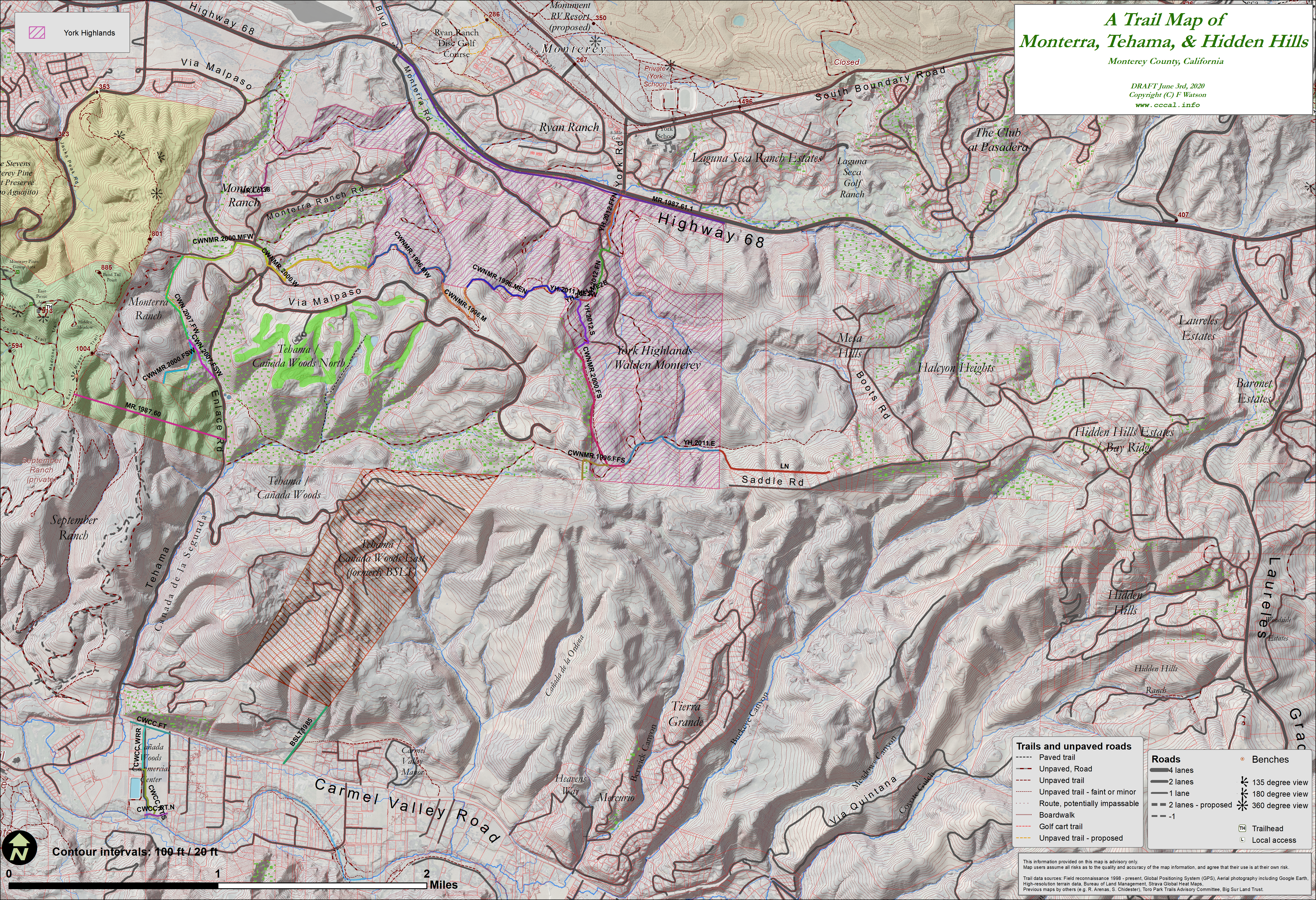
- The Ridge Trail - from Jacks Peak to Laureles Grade
Segments listed from west to east:
- MR.1987.60
Trail easement through Monterra Ranch's 115 acre addition to Jacks Peak park.
Land now owned by county. No trail exists.
Documented in:
- MR BOS Reso. 87-527. 1987 Oct 6. Approved Tentative Map. Condition 60.
- MR BOS Reso. 87-527. 1987 Oct 6. Approved Tentative Map. Condition 60.
- CWNMR.2000.FSW
Trail easement through Canada Woods North, connecting from 115-acre Jacks Peak. Connects from MR.1987.60 to CWN.2007.FW.
Rough slope. No trail exists.
Recorded in CWN Final Map Phase-3 2007.
Documented in:
- CWN Final Map Phase 3. Sheets 2 & 8. 2007 July 12. (Map 286. SN: 28624) (Vol 24 C&T Pg 8)
- CWN Final Map Phase 3. Sheets 2 & 8. 2007 July 12. (Map 286. SN: 28624) (Vol 24 C&T Pg 8)
- CWNMR.2007.FSW
Trail easement through Canada Woods North, connecting from 115-acre Jacks Peak. Connects from MR.1987.60 to CWN.2000.FW.
Rough gully. No trail exists.
Offered 2000 and not accepted. Modified and offered again 2001 and accepted. Recorded in CWN Final Map Phase-3 2007.
Documented in:
- CWN OTD. 2000 Feb 10. Not accepted.
- CWN OTD. 2001 Dec 26. Accepted.
- CWN Final Map Phase 3. Sheets 2 & 8. 2007 July 12. (Map 286. SN: 28624) (Vol 24 C&T Pg 8)
- CWN.2007.FW
Trail easement through Canada Woods North. Connects from CWNMR.2000.FSW or CWNMR.2007.FSW to CWN.2000.MFW.
Rough gully. No trail exists.
Offered 2000 and not accepted. Modified and offered again 2001 and accepted. Recorded in CWN Final Map Phase-3 2007.
Documented in:
- CWN OTD. 2000 Feb 10. Not accepted.
- CWN OTD. 2001 Dec 26. Accepted.
- CWN Final Map Phase 3. Sheets 2 & 8. 2007 July 12. (Map 286. SN: 28624) (Vol 24 C&T Pg 8)
- CWN.2000.MFW
Trail easement beside or along asphalt road through Canada Woods North. Connects from CWN.2007.FW to CWNMR.2000.W.
Offered 2000 and not accepted. Modified and offered again 2001 and accepted.
Documented in:
- CWNMR.2000.W
Trail easement through Canada Woods North. Connects from CWN.2000.MFW to CWNMR.1996.MW.
Rough, forested slope behind homes. Either no trail exists or there's an old jeep trail through the woods in that location.
Offered 2000 and not accepted. Modified and offered again 2001 and accepted.
Documented in:
- CWNMR.1996.MW
Trail easement along boundary between Canada Woods North and York Highlands. Connects from CWNMR.2000.W to CWNMR.1996.M.
Possibly an overgrown jeep trail.
Offered 2000 and not accepted. Modified and offered again 2001 and accepted. Offered again 2012 and accepted again. Recorded in YH Final Map 2012.
Documented in:
- CWNMR.1996.M
Trail easement through Canada Woods North. Connects from CWNMR.1996.MW to CWNMR.1996.MEN.
Possibly an overgrown jeep trail.
Offered 2000 and not accepted. Modified and offered again 2001 and accepted. Recorded in CWN Final Map Phase-1 2000.
Documented in:
- CWN DEIR. 1996.
- OTD. 2000 Feb 10. Not accepted.
- OTD. 2001 Dec 26. Accepted.
- CWN Phase 1 Final Map. Map 251. Recorded 2000 Feb 10. SN 25169 + 25170 (Vol 21 C&T Pg 3)
- CWNMR.1996.MEN
Trail easement along boundary between Canada Woods North and York Highlands. Connects from CWNMR.1996.M to YH.2011.ME2W.
Possibly an overgrown jeep trail.
Offered 2000 and not accepted. Modified and offered again 2001 and accepted. Offered again 2012 and accepted again. Recorded in YH Final Map 2012.
Documented in:
- YH.2011.ME2W
Trail easement in York Highlands. Connects from CWNMR.1996.MEN to YH.2012.S and YH.2011.ME2E.
Steep chaparral slope.
Offered and accepted. Recorded in YH Final Map 2012.
Documented in:
- YH.2012.S
Trail easement in York Highlands. Connects from YH.2011.ME2W and YH.2011.ME2E to CWNMR.2000.FS.
Road constructed in mid-2016.
Offered and accepted. Recorded in YH Final Map 2012.
Documented in:
- CWNMR.2000.FS
Trail easement in York Highlands. Connects from YH.2012.S to YH.2011.E and CWNMR.1996.FFS.
Dirt roads and tracks.
Offered 2000 and not accepted. Modified and offered again 2001 and accepted. Offered again 2012 and accepted again. Recorded in YH Final Map 2012.
Documented in:
- YH.2011.E
Trail easement in York Highlands. Connects from CWNMR.2000.FS to LN.
Dirt roads.
Offered 2000 and not accepted. Modified and offered again 2001 and accepted. Offered again 2012 and accepted again. Recorded in YH Final Map 2012.
Documented in:
- MR Board Order. 1990 June 19. Condition 61 & Exhibit C - Trail 2.
- MR OTD. 1992 Sep 29.
- CWN DEIR. 1996.
- CWN OTD. 2000 Feb 10. Not accepted.
- CWN OTD. 2001 Dec 26. Accepted.
- YH Letter 2011 June 17.
- YH VTM. BOS Reso. 11-342. 2011 Oct 18.
- YH OTD. 2012 May 31.
- YH Final Map. 2012 May 31.
- LN
Trail easement through Lit Ng property. Connects from YH.2011.E to a road easement on chaparral that extends beyond the constructed portion of Hidden Mesa Rd in Mesa Hills West, and thence both north eventually to Boots Rd and south to Saddle Rd where there is a trail easement all the way to Laureles Grade.
Steep chaparral slope.
Offered and accepted.
Documented in:
- MR.1987.60
- The Ridge to Highway 68 Trail
- ...not detailed on this page yet, but see History page.
- Carmel River trails
- Three trail easements on the south side of Carmel Valley Road near Earthbound Farms, entitled as part of the original Canada Woods project.