The Monterey Gilia population at Tenth St, Marina
Preliminary data and analysis by Fred Watson, PhD.
Last updated: 5 Sep 2024
DRAFT, incomplete
IIf you notice errors, or disagree with my preliminary reasoning, please let me know.
- Overview
In my interpretation, unauthorized take of a legally protected plant Monterey Gilia (a.k.a. Sand Gilia, Gilia tenuiflora subspecies arenaria) occurred during the construction of the Home2 Suites on Tenth St within The Dunes specific plan area during 2024.
Based on enquiries with the City of Marina (Aug/Sep 2024), it does not appear that a CDFW Incidental Take Permit covers this activity.
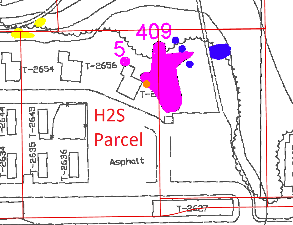
The population was first described in 2004 as overlapping what is now the hotel parcel. In 2020 a project biological consultant pointed out the population boundary from 2004 and re-surveyed twice in 2020 - finding no plants in the hotel parcel and fewer than 10 plants outside the hotel parcel. It is possible that city staff misinterpreted the consultant's survey results as implying that the population no longer occurred in the hotel parcel. For Monterey Gilia in particular, it is well known that surveys in a single year are insufficient to rule out continued occurrence in the seed bank. It should have been assumed that the 2004 population boundaries were still in effect, and a take permit should have been pursued (or the population avoided). It is implied from a project plan sheet that the project team regarded the Gilia patch as continuing to be a "biologically sensitive area". It was also a requirement of the MMP since 2005 that the entire 2004 population area be "[preserved] ... in place in perpetuity" (or a take permit obtained).
The continued occurrence of the population within the hotel parcel was affirmed in surveys by Watson in 2017 and 2019, providing evidence of long-term population persistence despite the low count in 2020.
If a take permit does not exist, an after-the-fact permit should be obtained from CDFW and my suggestion to CDFW would be that the mitigation should at a minimum include the following - keeping in mind that a perpetual but largely neglected preservation responsibility has been in place since 2005 for this and the other sites in the same development:
1. A comprehensive restoration of the entire native vegetation community surrounding the remaining portions of the Gilia population, preserving not just the Gilia but also the surrounding facilitating species such as sandmat manzanita (Arctostaphylos pumila), and removing the invasive trees, shrubs, grasses, and forbs.
2. Permanent legal protection in the form of conservation easement or fee title held by an appropriate organization e.g. an authorized land trust
3. Permanent physical protection in the form of fences that limit physical access but do not preclude visual public enjoyment of the native plant community
4. Perpetual funding
5. The same for the Twelfth St population
6. The opportunity for non-agency experts such as Dr Watson to review documents pertaining to planning for protection and mitigation, and monitoring for compliance.
(Note that two or three other historic Monterey Gilia occurrences fall within The Dunes specific plan area. One substantial population at Twelth St persists in a degraded condition, despite requirements for protection. Another single plant was found near California Avenue but no plants were able to be relocated by Watson in follow-up surveys about 15 years later; the area was graded for housing in 2023/24. A final population was mentioned near the old 12th St gate in the minutes from a 1996 working group meeting on rare plants, but it's precise location is unknown.)
- What is this page?
This page is intended as a place where I can explore, document, and communicate some of the details to involved parties such as CDFW & city staff. The use of a web page facilitates downloading of larger files. My motivation is to assure conservation of biodiversity.
- History
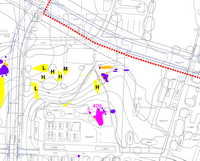
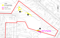
- 2004, April. Zander Associates mapped Monterey Gilia in three areas as part of the DEIR for University Villages, now renamed The Dunes at Monterey Bay
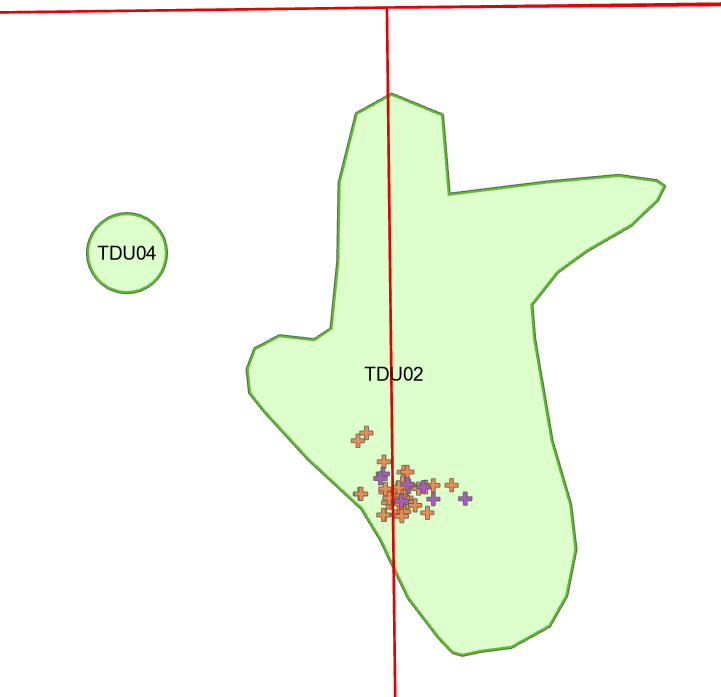
- Near Tenth St (Elements TDU02 & TDU04) - 414 plants
- Near Twelfth St (Element TDU01) - 367 plants
- Near California Ave (Element TDU03) - 1 plant
(The element numbers above are from Watson's inventory of all known elements of the Monterey Gilia taxon)
The Tenth St population is the focus of this page. It was overlapped by the Hotel2 Suites construction.
Original maps from the DEIR
Full size Cropped Whole project
(incl. Tenth St)
Twelth St 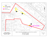
California Ave 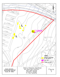
Relationship to boundary of Hotel2 Suites parcel boundary (red rectangle at left):
- 2005, May. The FEIR for University Villages was certified, including a Mitigation Monitoring Program (MMP) which stated:
"Project applicant shall avoid areas containing sand gilia during construction of the Proposed Project and preserve these populations in place in perpetuity or ..."
"Project applicant shall acquire a California Fish & Game Code, Section 2081 Incidental Take Permit from the CDFG. Required mitigation for the loss of this species and its habitat will be indicated as a condition of the permit."
2005_05_Univ Village Final EIR - Cert by Council 5-05_MMP.pdf
- 2017 – Watson commenced a taxon-wide status assessment of Monterey Gilia.
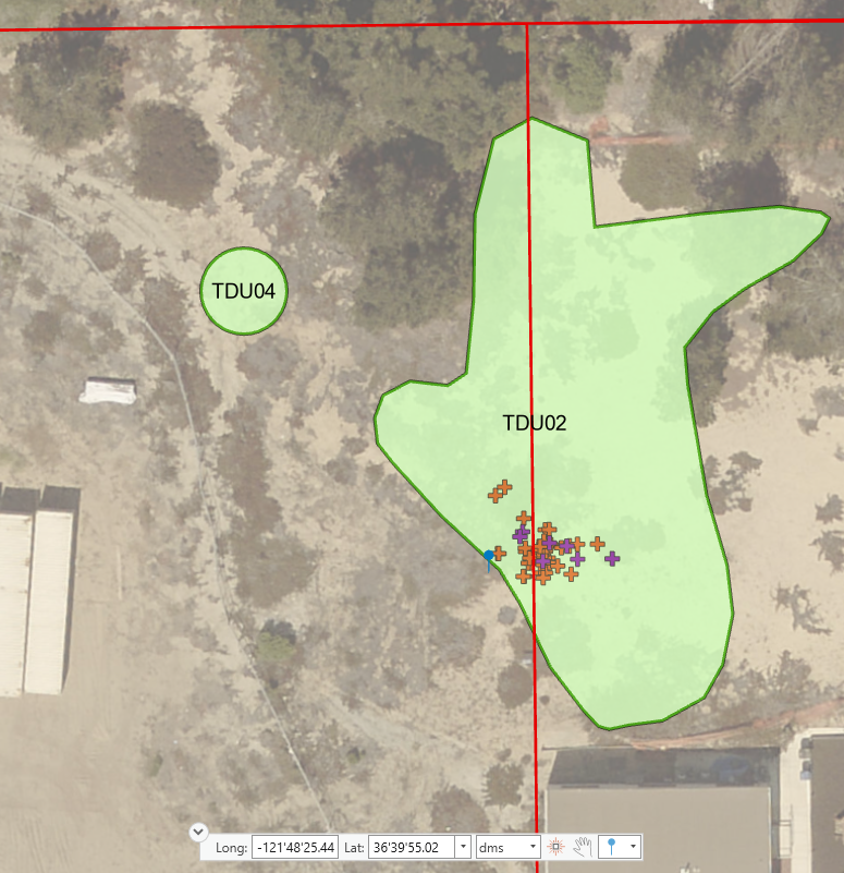
- 2017, April 29th. Watson GPS'ed 7 clusters of 1-10 Monterey Gilia plants at TDU02 as part of a status update for the entire taxon. The goal was primarily to document presence, absence, and general distribution of plants, and not to achieve a precise count. TDU04 was not surveyed.
- 2019, April 9th. Watson GPS'ed 36 clusters of 1-10 Monterey Gilia plants at TDU02 and did not detect plants at TDU04. Photos from that date (below) suggest that there were over 100 plants at TDU02. Watson returned on the 28th to make detailed photographic observations of plant morphology.
The GPS locations of the Watson observations are shown below for 2017 (purple) and 2019 (orange).It should be noted that in all years (2004, 2017, 2019) mapped observations fell on both sides of the parcel boundary.
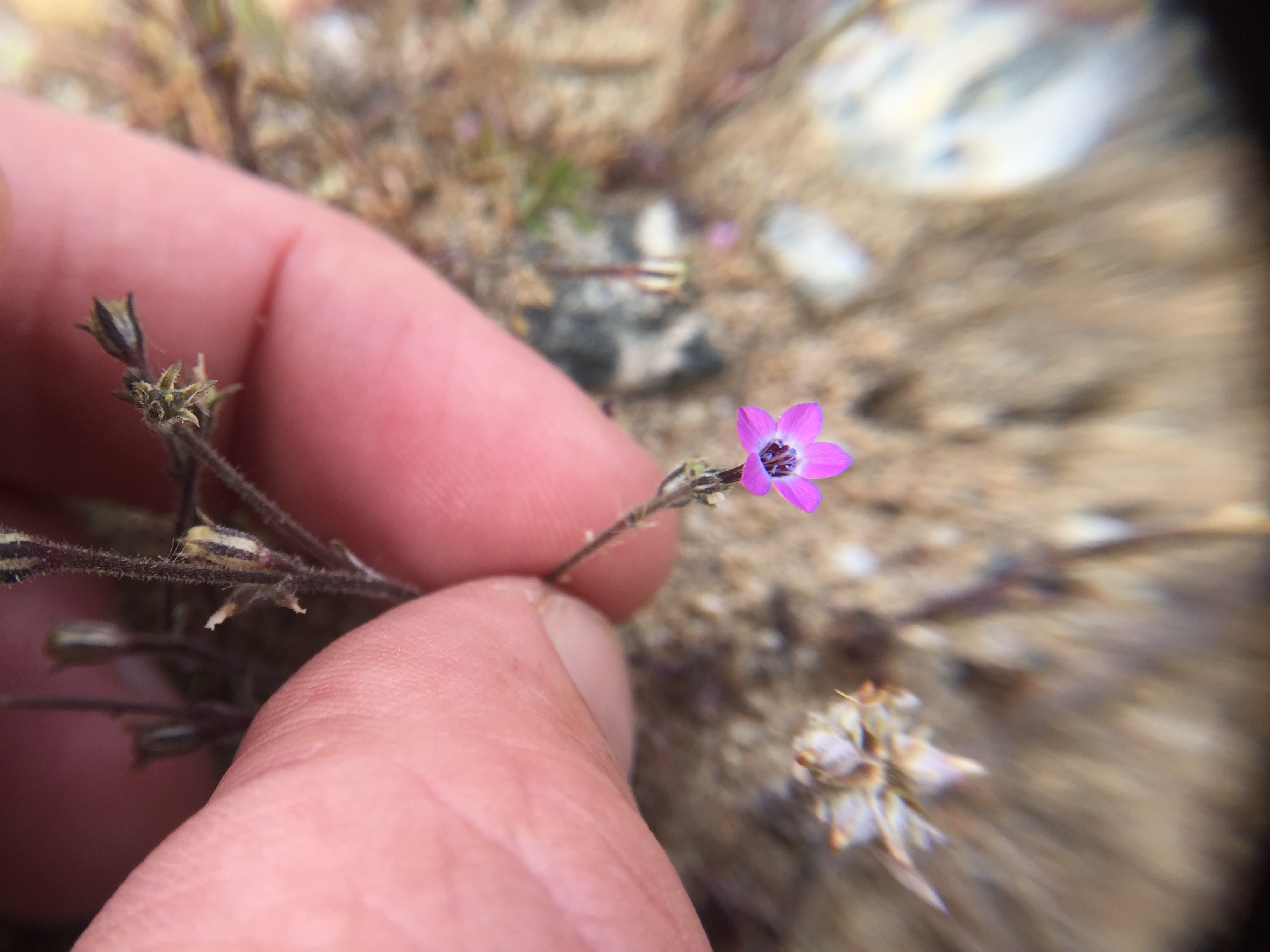
Monterey Gilia plants (lower left) at TDU02 4/29/17:
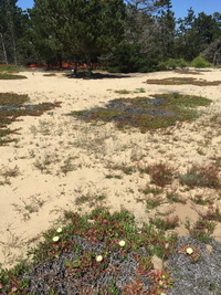
Approximately 100 Monterey Gilia plants at TDU02 on 4/9/19:

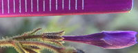
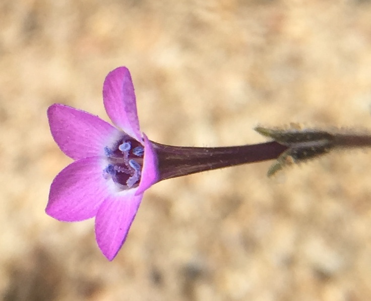
Morphology of flowers at TDU02, confirming that the population exhibits the protected subspecies arenaria. Calyces are densely glandular. Stigmas are among stamens and not strongly exserted from the corolla throat.
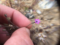
Monterey Gilia plant inside the hotel parcel (left), and map marking the location with a blue pin (right; based on the GeoTag of the photograph).

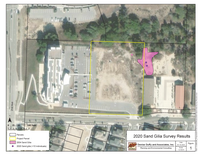
- 2020 - March 18 and April 30. Biological consultants surveyed the future hotel site for Monterey Gilia. No plants were observed in the hotel parcel. Fewer than 10 plants were obsereved in the adjacent parcel.
The biologists' report shows the location of the plants mapped in 2004, as well as the plants mapped in their 2020 surveys.
The report advises:
"Final grading plans and/or project plans depicting limits of disturbance should be reviewed to confirm avoidance of all sand gilia populations occurring within the site. If avoidance is not feasible, an incidental take permit from the California Department of Fish and Wildlife would be required."
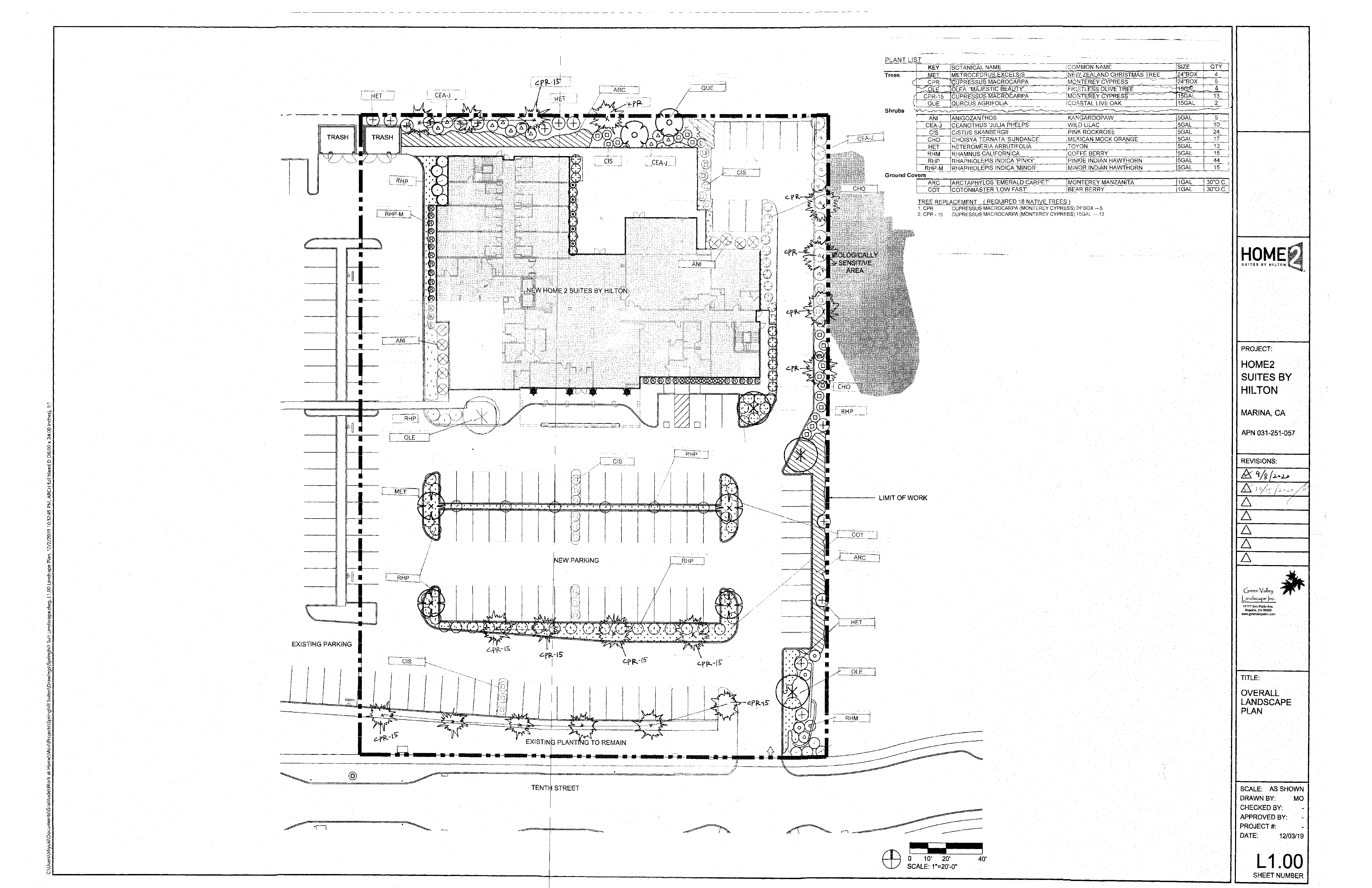
The hotel plan sheets also indicate a "Biologically sensitive area" in the location where Monterey Gilia were mapped in 2004, depicting the area as abutting the project closely enough as to give the implication that the project overlapped a portion of the Monterey Gilia area.

Biologist report:
PCAGDPKT_102220_Home2SuitesItem_ExhibitCBiologistsReport.pdf
Full Planning Commission packet containing the above:
PCAGDPKT_102220.pdf
- 2020, August 25. Watson GPS data from 2017 & 2019 transmitted to USFWS as part of the USFWS 5-year Review of the subspecies.
- 2022, October 22. The hotel project came before the Planning Commission of the City of Marina. Meeting minutes indicate unanimous approval, with no discussion of the Monterey Gilia.
As far as I know, the Planning Commission approval was sufficient within the municipal administrative framework, and the project did not need to come before the City Council.
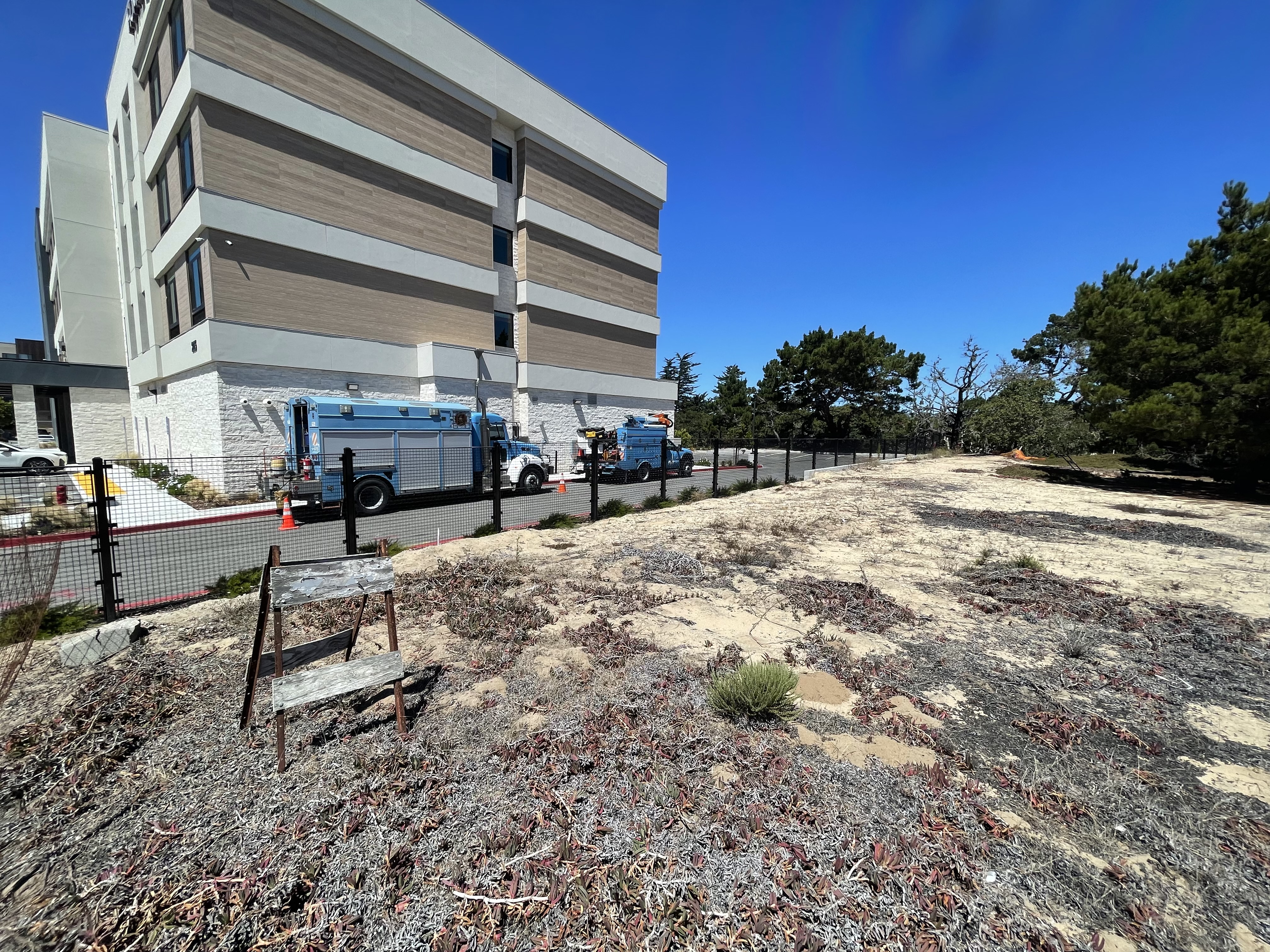
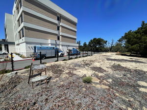
- 2024. The hotel was constucted and all areas within the hotel parcel were graded. A north-south fence was constructed about 7 feet west of the existing adjacent building. Retaining walls were constucted about 2 feet east of the fence. And excavation and spill occurred a few feet east of that, approximately matching the parcel boundary. West of the fence, everything was paved.
The image below was based on a 2024 Google Earth image approximately georeferenced by Watson, with the 2004, 2017, and 2019 data overlaid. It shows the hotel in mid construction.
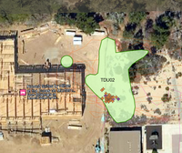
The construction was essentially complete when observed in August 2024, including paving of all areas within the parcel boundary. The fence in the photo below runs through the population as mapped in 2004 and re-affirmed in 2017 and 2019.
- 2004, April. Zander Associates mapped Monterey Gilia in three areas as part of the DEIR for University Villages, now renamed The Dunes at Monterey Bay