| History and status of Monterey County trails: September Ranch |
Back to index |
|---|
Fred Watson, PhD
(Copyright (C)). With Mike Weaver and Richard H. Rosenthal
- 2004, December. Draft Revised EIR
- 2006, February. Recirculated Portion of Draft Revised EIR
- 2006, July 19. FEIR
- 20016, December 4. Revised Vesting Tentative Map
- 2009, August. Revisd Water Demand Analysis 2009 Recirculated Portion of the Final Revised EIR
- 2010, Sept. 8. September Ranch before Planning Commission
- Includes Vesting Tentative Map
- Includes Vesting Tentative Map
- 2010, Nov. 9. Final Revised EIR before BOS
- 2011, August 10. Extension of Development Permit before Planning Commission
- 2013, March 27. Extension of Development Permit before Planning Commission
- 2018, Feb. 23. Devlopment sold, as reported in Carmel Pine Cone.
- 2019, November 5. Map of proposed trail system at September Ramch
- 2020, November 13, 17, 27. Offer To Dedicate trail and fee title to parcels
surrounding trail (include maps of trail and parcels C & D)
- 2020, December 8. Before BOS:
- Final Map Phase 1
- Irrevocable offer to dedicate and construct a public trail
Below are notes sent to county staff ahead of this meeting, and a subsequent erratum issued by county staff.
- Notes ahead of this meeting:
- Restictions to "daylight hours" should be removed (In clauses A.II.(a).5,
B.II.(a).3, C.II.(a).3). These were not in the original project approvals and associated conditions. They erode the public right in favor of the developer. "Daylight hours" conditions should not be deeded restrictions. Instead, they should be handled as policy and regulatory issues, subject to change. The county needs to retain the option to grant after-hours public access in the future, for activities such as ranger-led owl watching or graduate student bat research.
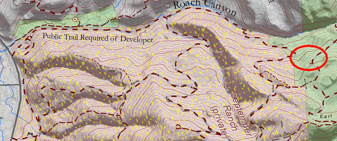
- BOS should be made aware that the trail specified in the Offer would not connect to existing public trails entirely through public land. Instead, the trail connects to existing untracked land within Jacks Peak County Park. To connecting to existing trails within the Park, an additional 600 feet of trail would need to be constructed through pine forest. Note that the trail specified in the offer does currently connect to existing trails within Jacks Peak Park via a brushy route that intersects approved private home lots, but it does not do so entirely through public land.
Note also that the current Monterey County General Plan states that it is the county's "highest priority" to establish trails systems that specifically include "a permanent riding and hiking trail from Roach Canyon to Jacks Peak Park". This trail in September Ranch is specifically intended to fulfil that county General Plan goal, which stands to today and originated in 1971 (see this page for more history). To stop 600 feet short would be to fail to meet the intent of the conditions placed on the approval of September Ranch.
The map below shows the gap - highlighted in red - between the offered trail and the existing public trail system in Jacks Peak County Park.
For orientation, Carmel Valley Road is at the left edge of this map, and Jacks Peak County Park is at the right edge.
- BOS should be made aware that the Offer refers to the obligation to "constuct" a trail, but the vast majority of this trail already exists as an old ranch road or horse trail. The developer's practical responsibility is thus merely to clear some brush and perhaps install some erosion control measures.
- Prior to the BOS meeting, county staff should provide additional documents in order to facilitate adequate public review of this action:
- A fully readable PDF copy of the Vesting Tentative Map (from around 2010). All posted copies contain unreadable text in annotations near the trail location. The original approval conditions specifically reference the VTM, but no readable public copy of the VTM appears to be available. With this, it is impossible for the public to accurately interpret the original approval conditions and whether the current Offer meets them.
- Electronic GIS or CAD files (SHP or DWG) of the trail alignment and parcelization, to allow the public to overlay these layers on other maps for comparison.
- A fully readable PDF copy of the Vesting Tentative Map (from around 2010). All posted copies contain unreadable text in annotations near the trail location. The original approval conditions specifically reference the VTM, but no readable public copy of the VTM appears to be available. With this, it is impossible for the public to accurately interpret the original approval conditions and whether the current Offer meets them.
- Restictions to "daylight hours" should be removed (In clauses A.II.(a).5,
B.II.(a).3, C.II.(a).3). These were not in the original project approvals and associated conditions. They erode the public right in favor of the developer. "Daylight hours" conditions should not be deeded restrictions. Instead, they should be handled as policy and regulatory issues, subject to change. The county needs to retain the option to grant after-hours public access in the future, for activities such as ranger-led owl watching or graduate student bat research.
- Erratum that resulted from the above notes
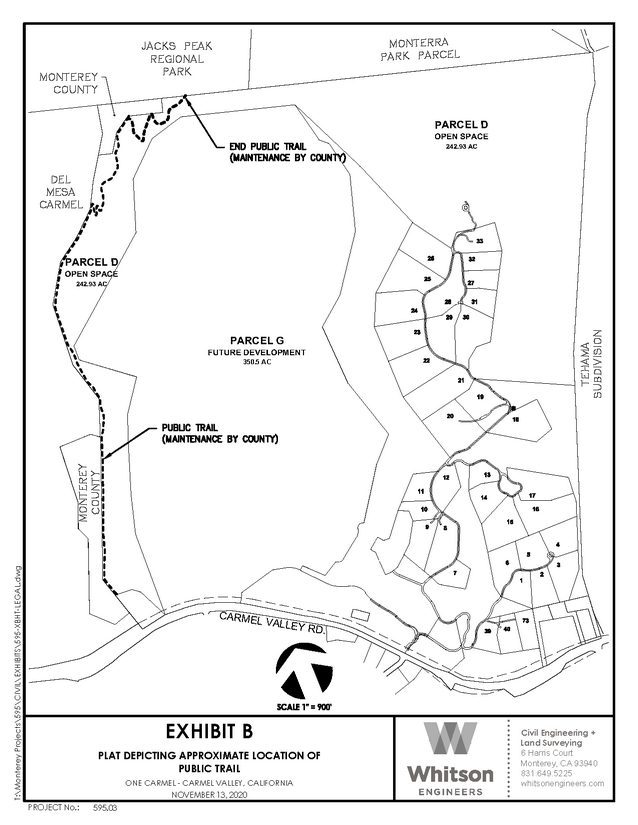
Map was revised to make a better connection to Jacks Peak park.
- Notes ahead of this meeting: