Some history and questions about Sand Gilia at Sea Haven (formerly Marina Heights)
F. Watson, PhD. Feb-Sep 2020
Overview
The Marina Heights / Sea Haven site experienced some take in about 2006, but I have not been able to find a description nor physical evidence in the field of any of the required mitigation having been completed.
This raises a number of questions that are at the bottom of this page.
History
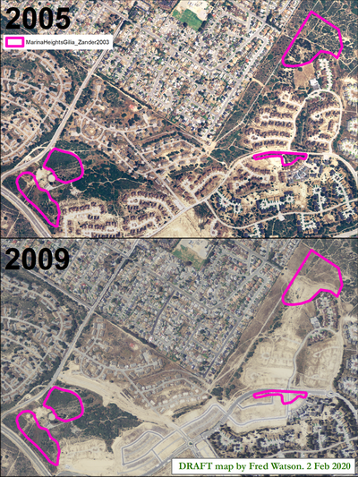
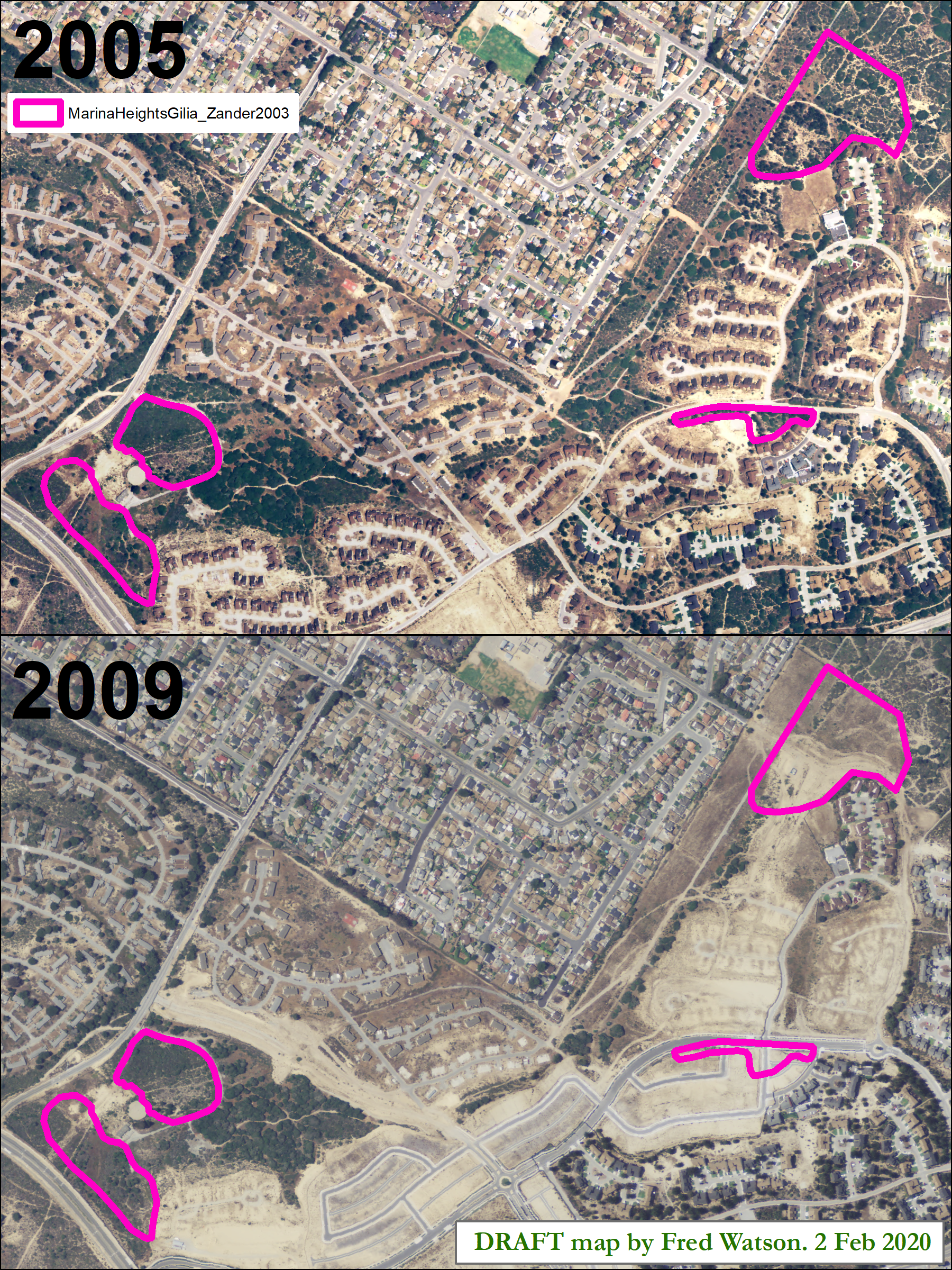
- 2003 April - In anticipation of development, biological surveys for what is now Sea Haven were done by Zander. Four Gilia polygons were delineated, as shown in this map:
- 2003 July - DEIR for Marina Heights, included Zander's map.
- 2004/5 - Mitigation plan developed (by DD&A?) as part of application for Incidental Take Permit.
- The Mitigation Plan required that, prior to grading, two letters of credit totalling $2,326,977 to be posted - for land acquisition and restoration implementation.
- The Mitigation Plan required that, prior to grading, an endowment fund would be created totalling $200,044 - for mitigation land management.
- 2005 - Incidental Take Permit 2081-2005-029-03 issued, with mitigation plan attached.
- 2006/7 - Substantial grading and grubbing occurred in two of the polygons visible in 2007 & 2009 aerial imagery. The area of these polygons is about 14 acres. Take would certainly have occurred.
- 2008 - MOA between FORA, County RDA, & Marina Heights regarding use of Landfill site as mitigation receiver under the 2004/5 mitigation plan.
- 2010 June 30 - Take permit expired (according to 2012 letter, see below)
- 2012 - Letter from CDFW to Marina Heights developer noting that 14.5 acres of take had occurred and commenting on the possibility of phasing the mitigation in relation to this.
- 2016 - approx? - development transferred ownership (?) from Marina Heights to Sea Haven
- 2016 - Sea Haven item before Marina DRB, includes a Gilia-related condition implying that no current take permit exists for Gilia
- 2017 - First homes built at Sea Haven, after site lay idle for about 10 years since road construction in 2007.
- 2020 - Construction active. Items before council. Some of the original Gilia polygons may be intact but remain zoned for development.
- 2020 - Sep - City agrees to take ownership of Landfill border parcels from County
Questions
The above history leaves me with some questions that I think have bearing on the overall potential for recovery of Sand Gilia under CESA & ESA. Perhaps these are simple questions with simple answers, but if the answers are simple, they are not readily apparent from the public perspective:
- Were the $2.3M letters of credit posted? What is their current status, and the status of any actions they were intended to assure?
- Was the $200k endowment created? What is its current status, and the status of any actions it was intended to assure?
- Has any actual mitigation for the "14.5" acres of take occurred?
- What is the current plan for future development and mitigation at Sea Haven in the Gilia polygons mapped by Zander in 2003, particularly in the not-yet-developed polygons that may still support substantial amounts of Sand Gilia?
- Has the city or a developer instituted any physical survey of Sand Gilia at Sea Haven since the 2003 Zander surveys?
- Does a current take permit exist for any remaining take of Sand Gilia at Sea Haven?